Saturday, March 12, 2011

Galapagos: Take 2

The 5 am wake up call was worth it as we were the first in the queue at the airport.  Unfortunately, no one seemed to have a clue as to what to do.  After a few minutes, we were given handwritten boarding passes.  Hmmm.....  Oh well, Step 1 completed.  We were happy, but don't get too excited as we still have fears that we might get bumped from the flight.

We boarded the plane, but there are people in our seats.  Oh no!  No worries.  Due to confusion, LAN has decided to do free seating, Ryanair style.  Step 2 done.

We had a stopover in Guayaquil and had to disembark.  Another chance to be bumped.  After 30 minutes we successfully boarded the plane again.  Whew.  Step 3 ticked.

After a bit of a bumpy ride, we touched down in Galapagos.  Step 4 finished!  We made it and it was sunny and hot.  Animals, here we come!  


Fly, no fly, fly?

After a long day and some intense discussions with the LAN personnel, it seems that we may eventually with a bit of luck fly, if there are any planes leaving to the Galapagos.

The way it works in LAN's world is interesting: as tickets' holders from 11/03, we would have priority over the passengers who are flying on 12/03... and kick them out of their seats.

It's a very much customer focused approach. We'll see how it goes.
On its side, the local competitor airline TAME has taken a boring approach by organising a couple of extra flights.

As of 11pm local time (4am GMT) we "will" fly as no tsunami will hit the Islands. See article in Spanish.

Friday, March 11, 2011

Tsunami alert in the Galapagos - we are safe in Quito

We woke up this morning at 5 to head to the Galapagos.As we got to the airport, we first understood there would be delays because of "weather conditions".  A few minutes later we were told our flight got cancelled as an 8.9 quake hit Japan yesterday and a tsunami wave is now heading towards Ecuador.

We were obviously really disappointed and we only realised how bad it was in Japan when we left the airport. A taxi driver told us Ecuador as well as Chile, Peru, Colombia and Panama are in state of emergency

The isla Baltra where we were supposed to land is being evacuated and all the flights for the next few days are fully booked. It's not looking good.

We now have 4 options:
1- Lose our tickets, which is not really appealing
2- Postpone the flight until March 2012
3- Get lucky and manage to get a flight tomorrow if no damage is reported on the island
4- Take another flight to the city of our choice for the same price

We'll let you know how it goes.

We of course hope the Galapagos will be spared. Fingers crossed

Thursday, March 10, 2011

Trip to "middle earth" - Quito

2 months after we last sniffed kerosene, we are back to the airport.
Hugo, the owner of the hostal "El Mirador del Inka" in Cusco kindly dropped us off this morning at 6am. This hostel is really nice and the owners are really helpful and friendly. They also provide tours and we got a wicked one. The hot water was not working all the time but we survived without it.

Anyway... Our flight in Cusco was delayed from 8.15am to 10.30am and before we started worrying about our correspondence, LAN put us on another flight and we arrived on time in Lima. A few hours later we found ourselves in Quito, chatting to Manuel, the local cab driver who starts his days at 5am to finish them at 10pm. He advised us to visit "La mitad del Mundo", 20km north of Quito, the 0'00''00 latittude point.

Think about Greenwich meridian but this one is the main horizontal one instead. It is also called the "Equateur". On the equateur, the water doesn't rotate clockwise or anticlockwise and there are no tornadoes as the opposite forces of Earth cancel each other. That sounds like a film but it is called the acceleration of Coriolis effect. Read about it when you have a minute. It sounded cool enough to go straight there before even dropping our bags at the hostel. We also thought it was a good idea to leave our bags in the taxi, and let the taxi driver to look after it. It actually was a good idea. When we came back Manuel was still waiting and we were secretly relieved.

In the evening we met Yvonne from the Uyuni tour, as well as Dave and Kirsten whom we've met in la mitad del mundo, in Quito's Old town for dinner. It was nice to chill but the local groups came one after another and played a couple of songs before  asking for tips and leaving. It felt like a loud jukebox for which you have to pay for all the songs, but in some ways it gave us a real taste of the local culture.

We don't have time to visit Quito any longer as we are off at 5am to fly to the Galapagos. We can't wait to send you a post from there.

Ciao


Tuesday, March 8, 2011

Mist-ical Machu Picchu


Due to limited time and Yumi's constantly cramping stomach, we opted for the 2 day tour of Machu Picchu rather than the 4 day trek.  Along with our new Swiss German friends Adriana and David and a German lady Ute, we travelled by private car to the concentric terraces of Moray and the never ending salt pools of Maras.  

For those who want to know: Moray is an archaeological site located on a high plateau at about 3500 m and just west of the village of Maras. The site contains unusual Inca ruins, mostly consisting of several enormous terraced circular depressions, the largest of which is about 30 m deep. The purpose of these depressions is uncertain, but their depth and orientation with respect to wind and sun creates a temperature difference of as much as 15 °C between the top and bottom. This large temperature difference was possibly used by the Inca to study the effects of different climatic conditions on crops.  


Since pre-Inca times, salt has been obtained in Maras by evaporating salty water (provided by a nearby subterranean stream) in the sun, leaving the salt behind. 
The highly salty water has been flowing from this nearby stream for hundreds of years. A main channel flows across the mountain and trickles down to all the pools below. As the salt water becomes supersaturated, salt crystals begin precipitating out of the water. 

The farmers then scrape the salt to the side and collect it once a sizable amount has been gathered. Some salt is sold at a nearby gift store.

There are about 4500 pools. The salt is exported all over the world and apparently this is a salt is not special in any ways, it's just salt.


From Olantaytambo, we caught a surprisingly nice train to the town of Aguas Calientes.  After a quick briefing from the guide, we hit the sack as we needed to be up in 5 hours.
We were greeted at 4am by pouring rain.  Thank goodness we found an overhang to stand under as we queued for the bus.  Why so early?  Only the first 400 visitors can get tickets to climb Huayna Picchu, the mountain you see in the background of most postcards of Machu Picchu.   
The buses started making the journey down the narrow road at 5:30am.  Success!  We got tickets to climb Waynu Picchu at 10am.  We hoped the weather would clear up by then.  (NB you have to show your passport to get on the train and to enter Machu Picchu).


Machu Picchu is truly a mystical place, especially in the mist.  Every once in awhile, the clouds would part and we could see that we were surrounded by mountains.  It is amazing that this place was ever built and later re-discovered.  75% of the city is in its original condition and only 25% has been restored.  The craftsmanship of the Incas is remarkable.


The guided tour was very informative, but unfortunately we were a group of 20 taking the same route as all the other tour groups.  It was difficult to get a photo without other tourists in the background.  
The cimb up Huayna Picchu is not easy, but we found it to be a breeze compared to the climbs we had done at much higher altitudes.  We weren't out of breath after just a couple of steps.  The stone steps became slippery as the rain started pouring down.  Unfortunately, when we reached the top the view of Machu Picchu was obscured by the clouds.  


After 35 minutes of sitting in the rain, we decided to descend.


About 40 minutes later as we were making our way to the exit, we turned back to see that Huayna Picchu was clearly visible.  Doh!  Oh well, the climb was still worth it.


We debated whether to walk in the rain to see the Sun Gate and the Inca bridge, but we were cold and wet and couldn't be bothered anymore. (Hint: it's worth buying a plastic poncho for £1.  Waterproofs can only handle rain for so long).  Back in Aguas Calientes, happy hour started at 4pm!  Pina coladas for £1.  We were definitely happy.

Friday, March 4, 2011

Isla del Sol

Hey All,

Another day, another adventure. Today's plan was to go to Isla del Sol, "the birthplace of the Inca culture". It's not exactly it actually. The Incas came after the "Tiwanakus" -a pre-Inca culture- and the Isla del Sol is the capital of the Tiwanaku culture just like Cusco is to the Inca culture. 
At least that's what I understood. Ish.


The "Sun Island" is located on Lake Titicaca, about 2h by boat from Copacabana. We decided to be dropped on the north side of the island, get a guided tour of the ruins and walk 11km (7 miles) south where the boat would pick us up again.  Of all the people on our boat, we were the only people to walk! It was only a 3h walk at 4200m above see level. 

The island looks like Corsica, but not as nice. Of course :)

The weather was awesome and the mediterranean style landscape great. The highest point of the island is 4250m above sea level and you can feel it when you go uphill. It took our breath away to take the following picture!
 
The only "downside" of this stunning place is that we have to go through several "checkpoints" and pay an "entry fee". Each one of them (3) was 5 bolivianos (about 50p) so it's nothing much and by talking to the locals we understood this helps to pay for the kids' school and any needs they may have. We also learned that the locals' lifestyle has improved a lot since more tourists come to the island so we gladly pay for it. We had to convince some French and a German to pay the fee as they were trying to get away without paying. We try to stay away from these "tourists".
On the way we met Dan, Karen, Chris and Debbie from England. Chris and Debbie used to live about 3 minutes walk from our place in Clapham Junction and Debbie used to work with the person who helped us book our Round the World trip at Trailfinders! The world is such a small place.
We are now heading to Cusco...

Tuesday, March 1, 2011

ruta de la muerte - death road


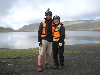
Built in the 30s and "closed" to traffic in 2005 (ish) more than 85.000 people have died on this road. That's about 5 deaths per day over 70 years, hence the nickname. It is also called the Coroico Road or the "Camino de las Yungas", but names like this are a bit boring.


Yumi, Yvonne and I booked a last minute ride with "Gravity" on sunday night for monday morning. Only a few riders (18) have died on this road since 1998 but to be honest, to fall of the cliff, you need to:
- be drunk
- not knowing how to use the breaks
- lack common sense
- think you are much better than what you are
- be really unlucky

Contrary to what people think, it is not a dangerous road if you are on a mountain bike. It is wide and not steep. If you want to have fun though, you need a double suspension bicycle otherwise you may walk funny once you reach Yosala, the little village at the bottom of the valley.

We started at La Cumbre ("summit" in Spanish) at 4650m, some 700m above La Paz. Just like London, it takes you ages to get out of the city and then if you manage to avoid dogs, oncoming traffic (the bigger trucks have priority), pedestrians, potholes and mudslides you'll get there.


We went downhill on paved road for about 1h30  -to get used to the bikes- before reaching the Death Road. I guess we reached about 60km/h, which is not bad on a double suspension mountain bike.

It will take you about 4h30 to do the 55km on The Coroico Road, some sections are really long and fun. You have to ride on the left hand side though, quiet close to the cliff, which makes it really interesting at some points. 


Overtaking is easy but make sure you tell other riders where you are going to pass, otherwise some may panick and crash.
Just like this:
we got drenched in rain, cycled under cascades, crossed rivers, crossed a mudslide with our bikes (we had signed a "if-you-die-it's-your-fault" form) and tasted tropical weather (as the bottom is at 1500m above sea level). 


The change of weather hits you at one corner, you feel like you are cycling into a hairdryer. It was an amazing ride, if you have the chance to do it: Do it!

PS: Thomas decided to accept the guides´challenge and go 45minutes uphill and climb "heartbreak hill". At 4200m above sea level. "That´s %&¿?$# hard", he later said. But he made it. :)